![[object Object]](https://umsousercontent.com/lib_iJnHWwbdmuXMWCqO/3xn3bx3wzrjdmko7.png?w=400)
Precision and detailed measurements can set your instant quotes apart from the competition. One of the most impactful tools available for achieving this is high-definition aerial imagery.
At Deep Lawn, we leverage Nearmap's advanced high-definition imagery - updated every 3-4 months with an impressive 6 cm resolution. Here’s why Deep Lawn's HD imagery is a game-changer for new development areas and how it can enhance your sales process.
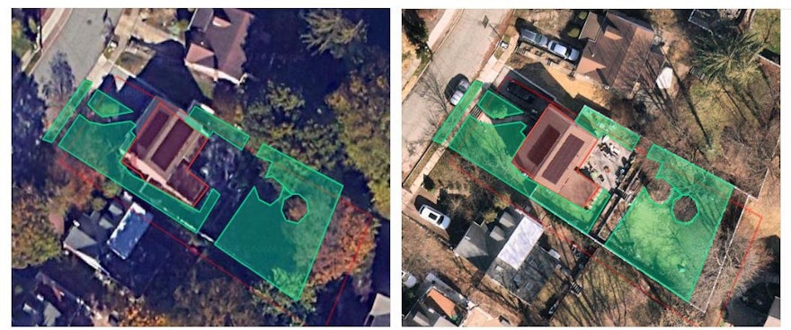
Standard Imagery vs. HD Imagery


Standard imagery - lots of leaves (top); HD imagery - leaves off (bottom)
Deep Lawn's HD imagery provides a detailed view of properties, enabling precise measurements of lawns, buildings, sidewalks, and driveways. Our AI integrates both standard imagery and the latest "leaves-off" images to provide up-to-date measurements, which will be discussed later in this section.
This combination is particularly effective for managing heavy canopies - which can be particularly challenging - as briefly discussed in our AI and Tree Coverage blog post. By having HD imagery, the AI can see through the trees and accurately identify turf and other features that standard imagery might miss.
Thus, if heavy tree coverage remains one of your biggest concerns, or if you are worried if the AI can differentiate the turf - Deep Lawn's HD Imagery is your answer.
Staying Up-to-Date (New Developments, Rapidly-Growing Areas)


New development area with standard imagery (top); New development area with HD imagery (bottom)
Deep Lawn's HD Imagery is updated every 3-4 months, ensuring that you always have the latest aerial images of a property. This frequent updating is important for viewing new developments, such as recent construction or landscaping changes.
With HD imagery, you can provide instant quotes based on the latest data, even in fast-growing and newly developed areas, ensuring that your measurements are both accurate and timely.
Look-back Periods

HD Image Taken (look-back periods available)
The historical data available through Nearmap allows you to view a timeline of HD images taken over several months and years in Deep Lawn.
This feature is invaluable for tracking changes to a property, such as the impact of different treatments, seasons, or as discussed above - heavy canopy or new developments. By analyzing past images, you can gain insights into long-term trends and adjust your lawn care strategies accordingly, ensuring a well-informed and proactive approach to your targeted service areas.
click here for a brief video on how to easily view those look-back period images.
Conclusion
While standard imagery offers useful data for companies to still receive an accurate AI measurement in seconds of the lawn - Deep Lawn's HD imagery is crucial for navigating complex challenges such as heavy canopy coverage and rapidly changing areas. Utilizing HD imagery means staying at the forefront of the industry, offering unmatched detail and insights that set you apart from the competition.