— AI property measurements
Know every square foot before you quote
Type an address and Deep Lawn measures the lawn, lot, building, in seconds — accurate AI measurements that power every quote and online sale, no site visit required.

— AI property measurements
Know every square foot before you quote
Type an address and Deep Lawn measures the lawn, lot, building, in seconds — accurate AI measurements that power every quote and online sale, no site visit required.

Satellite or Aerial Imagery + AI
We source from multiple satellite and aerial imagery providers — and offer High-Definition aerial imagery for the properties that need it most.
Multiple imagery sources for nationwide coverage
Standard imagery and High Definition imagery plans
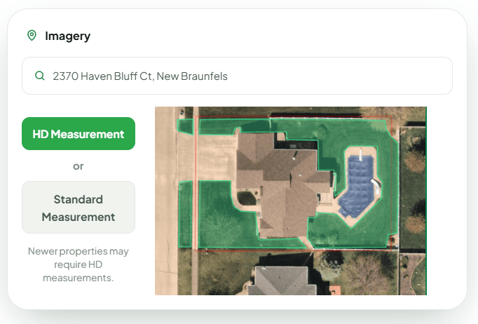
Choose the Right Imagery for Your Market
Deep Lawn offers two powerful imagery options so you can get accurate measurements for any property, anywhere in the US or Canada. Both imagery options deliver accurate AI measurements and instant quotes.
Standard Imagery
Fast, reliable coverage for most properties nationwide.
High-Definition Imagery
Higher resolution and more frequent updates for more challenging properties including heavy tree coverage and new developments.
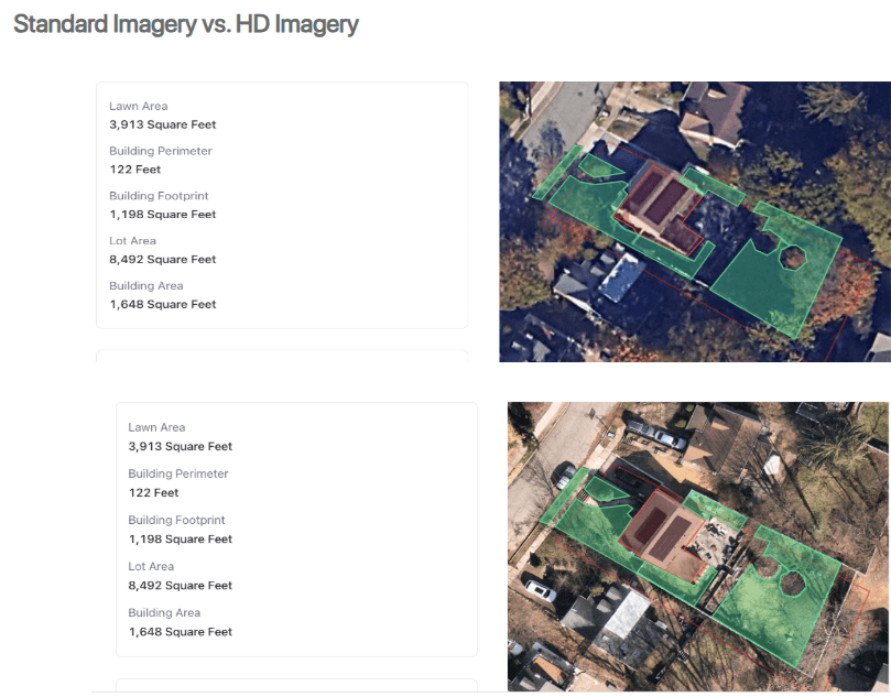
Deep Lawn's High-Definition Imagery
Our High-Definition imagery uses aerial imagery and is updated frequently based on area.
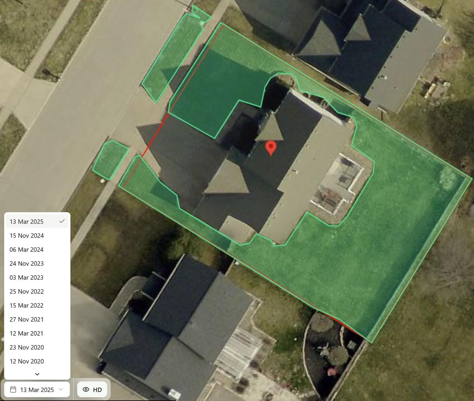
"Leaves off" look-back periods
Deep Lawn's AI measures off both the most recent image of the property and the most recent "leaves off" winter image — to see clearly through the trees.
Learn more on how HD Imagery can elevate your lawn care game →
Heavy canopy & new development areas
HD imagery is ideal for heavy tree-coverage areas, or regions you service with new buildings and developments.
AI Measurements | ✔️ | ✔️ |
|---|---|---|
Property Boundaries | ✔️ | ✔️ |
Higher Resolution Aerial Imagery | - | ✔️ |
Leaves-Off Imagery | - | ✔️ |
Look-back Images | - | ✔️ |
Ideal for Heavy Tree Coverage | Good | Best |
Ideal for New Developments | Good | Best |
— Customer Results
Some of Deep Lawn's Success Stories
Learn how companies drive sales, sharpen their competitive edge, and accelerate growth with Deep Lawn.

How Lush Lawn Enhanced Their Digital Sales and Competitive Edge With Deep Lawn
Deep Lawn presented Lush Lawn with the opportunity to provide customers with 24/7 access to purchase their services, meeting the increasing demand for online purchasing.....

How Emerald Lawns Optimized Operations and Accelerated Sales with Deep Lawn
Prior to Deep Lawn, the average time from customer interest to receiving an estimate was about three and a half days. Now, 16% of new orders were instantaneous through Deep Lawn's e-commerce platform...

How Pro Outdoor Optimized Sales and Service Efficiency with Deep Lawn
Within eight months of launching Deep Lawn, Pro Outdoors experienced increased online sales, particularly their irrigation membership packages.....
Frequently asked questions about our imagery
What imagery do you use?
Our standard imagery utilizes google and mapbox. Our High Definition imagery utilizes Nearmap and Eagleview.
How fast is your AI?
Our residential measurements typically takes 1-30 seconds to generate.
What all can your software measure?
Our AI can measure the Lawn, Driveway, Sidewalk and the Building on a property.
How does your imagery do with heavy tree coverage?
Our customers tell us that our AI does as good as what a human would do if measuring remotely. That said, there are some properties that have very heavy tree cover and the measurements are not as precise. What is great about our HD imagery is that we have leaves-off imagery available.
Is Deep Lawn's imagery up to date?
We have high definition aerial imagery available within Deep Lawn that is taken every couple of months with 6 cm resolution. Our standard definition imagery utilizes satellite imagery from a variety of satellite sources.
Get started with AI lawn & pest measurements today
See exactly what Deep Lawn returns for any address — then turn it into a quote your customer can buy online.